By 2050, 68% of the world's population will live in cities. That's 6.7 billion people competing for the same roads, the same public spaces, the same infrastructure that many cities are already struggling to manage today.
Jakarta alone loses an estimated Rp 65 trillion annually to traffic congestion. Mumbai spends 65% of its water supply to leaks and theft. São Paulo's air quality regularly reaches hazardous levels. These aren't problems that can be solved by simply building more roads or hiring more workers.
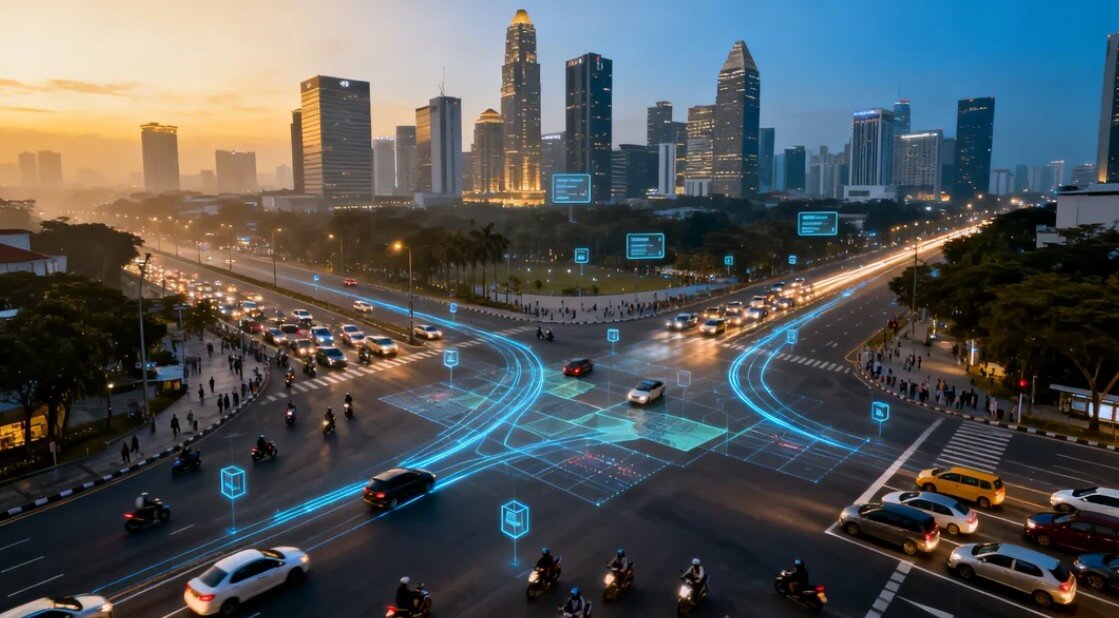
This is where computer vision—artificial intelligence that can see and interpret visual information—is fundamentally changing how cities operate. By transforming millions of existing cameras into intelligent sensors, cities are gaining unprecedented visibility into traffic flow, crowd density, infrastructure health, and public safety in real-time.
The result isn't science fiction. It's happening now, in cities across the world, including Indonesia. And it's creating urban environments that are safer, more efficient, and more livable than ever before.
What Actually Makes a City "Smart"?
The term "smart city" gets thrown around a lot, often vaguely. Let's be specific about what it actually means.
A smart city is one that uses digital technology and data analytics to enhance the efficiency of urban operations and services, improve quality of life for residents, and ensure sustainable economic development. The "smart" part isn't about having the latest gadgets—it's about using data to make better decisions.
Think of it this way: a traditional city is like driving with only your dashboard gauges—you know your speed and fuel level, but you can't see traffic ahead, don't know which routes are congested, and can't predict when your engine might fail.
A smart city is like having a full navigation system with real-time traffic, predictive maintenance alerts, and AI assistance suggesting optimal routes. You have visibility. You can anticipate. You can optimize.
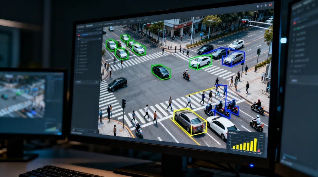
Smart City = Sensors + Connectivity + Analytics + Action. Computer vision provides the most powerful "sensor" by extracting rich data from visual feeds. A single camera can count vehicles, detect incidents, monitor crowds, identify infrastructure issues, and assess environmental conditions—simultaneously.
The Three Generations of Smart Cities
Smart City 1.0: Technology-Driven (2000s)
Technology vendors pushed solutions to cities. Projects were often siloed—smart traffic here, smart lighting there—with little integration. Results were mixed because technology was deployed without understanding actual city needs.
Smart City 2.0: Government-Led (2010s)
Cities took control of the agenda, defining problems they needed solved. Better outcomes, but still largely top-down with limited citizen involvement. Integration improved but data often remained in departmental silos.
Smart City 3.0: Citizen-Centric (2020s)
The current generation emphasizes citizen needs and participation. Technology serves clearly defined outcomes—reducing commute times, improving air quality, enhancing safety. Data is integrated across departments. Privacy and ethics are central considerations.
The Critical Role of Computer Vision
Of all the technologies enabling smart cities—IoT sensors, 5G connectivity, cloud computing, AI—computer vision stands out as perhaps the most transformative. Here's why:
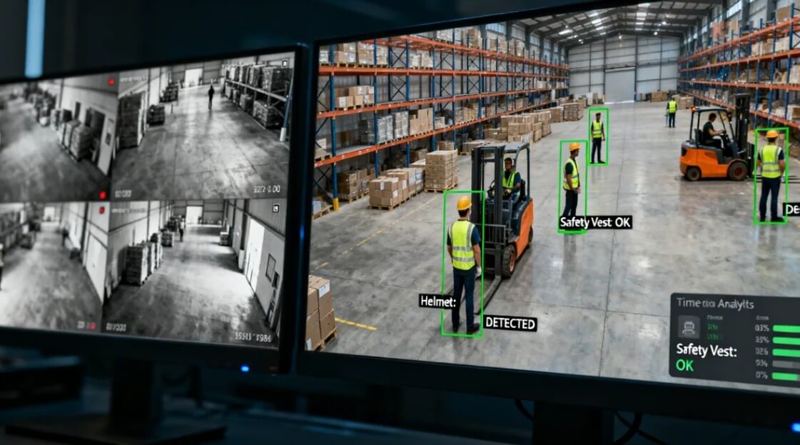
Cameras Are Already Everywhere
Most cities already have extensive CCTV networks. Traffic cameras, security cameras, public space monitoring—the infrastructure exists. Computer vision transforms these passive recording devices into active intelligent sensors without requiring new hardware deployment.
Visual Data Is Rich Data
A single traffic camera with computer vision can simultaneously: count vehicles by type (cars, motorcycles, trucks, buses), measure speeds, detect accidents, identify illegal parking, spot road hazards, and estimate queue lengths. Traditional sensors would need multiple separate devices to capture this same information.
Real-Time Understanding
Computer vision operates in real-time, analyzing video streams as they happen. This enables immediate response—traffic signals that adapt to current conditions, alerts when crowds exceed safe thresholds, instant notification when incidents occur.
5 Pillars of Smart City Computer Vision
Computer vision applications in smart cities can be organized into five major categories, each addressing critical urban challenges:
Intelligent Traffic Management
Traffic congestion costs cities billions annually in lost productivity, wasted fuel, and increased emissions. Computer vision enables traffic systems that respond to actual conditions rather than fixed timing schedules.
Key capabilities: Real-time vehicle counting and classification, adaptive traffic signal control, congestion prediction, incident detection and alerting, illegal parking identification, speed monitoring.
Public Safety & Security
From crowd management at public events to rapid incident response, computer vision enhances public safety while enabling more efficient use of security resources. The goal is prevention and rapid response, not surveillance for its own sake.
Key capabilities: Crowd density monitoring, anomaly detection (fights, falls, abandoned objects), perimeter protection for critical infrastructure, emergency evacuation guidance, integration with first responder dispatch.
Infrastructure Monitoring
Roads crack. Bridges deteriorate. Streetlights fail. Traditional inspection is manual, expensive, and infrequent. Computer vision enables continuous monitoring of infrastructure health, catching problems before they become dangerous or costly.
Key capabilities: Road surface condition assessment (potholes, cracks), bridge structural monitoring, streetlight malfunction detection, illegal dumping identification, drainage system monitoring during floods.
Environmental Monitoring
Urban air quality, flooding risk, and waste management are growing concerns as cities expand. Computer vision adds a visual dimension to environmental monitoring that traditional sensors cannot provide.
Key capabilities: Visible pollution detection (smoke, haze), flood water level monitoring, illegal burning identification, waste overflow detection, green space health assessment.
Urban Planning & Analytics
Long-term city planning requires understanding how people actually use urban spaces. Computer vision provides continuous data on pedestrian flows, public space utilization, and transportation patterns that inform better planning decisions.
Key capabilities: Pedestrian traffic analysis, public space utilization measurement, transportation mode analysis (walking, cycling, driving), seasonal pattern identification, event impact assessment.
Real-World Examples: Cities Leading the Way
Smart city concepts are impressive on paper. But what does implementation actually look like? Here are cities that have deployed computer vision at scale with measurable results:
Singapore's "Smart Nation" initiative is perhaps the most comprehensive smart city program globally. Computer vision plays a central role:
- Intelligent Transport: Over 6,000 cameras monitor traffic with AI, enabling adaptive signal control that's reduced average journey times by 12%
- Crowd Analytics: Real-time crowd density monitoring at MRT stations and public events prevents dangerous overcrowding
- Infrastructure: AI inspects roads for defects, prioritizing repairs before potholes become hazards
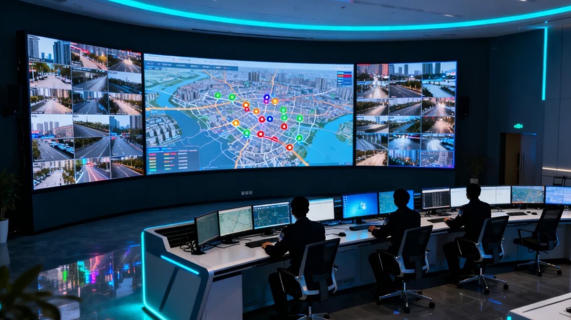
- Integration: All systems feed into a unified urban operations center for coordinated response
Alibaba's "City Brain" project in Hangzhou demonstrates the scale of what's possible:
- Traffic Optimization: AI analyzes feeds from 1,300+ intersections, automatically adjusting signals to optimize flow
- Results: Average commute times reduced by 15.3%, emergency vehicle response times cut by 50%
- Ambulance Routing: System clears traffic lights ahead of ambulances, creating "green corridors" to hospitals
- Parking: Real-time occupancy detection guides drivers to available spaces, reducing circling time by 40%
Dubai has prioritized public safety and operational efficiency in its smart city deployment:
- Oyoon (Eyes) Project: AI-powered cameras across the city detect accidents, congestion, and safety violations automatically
- Metro Monitoring: Computer vision tracks crowd density on platforms, triggering announcements and staff deployment
- Beach Safety: AI monitors beaches for drowning risk, alerting lifeguards to struggling swimmers
- Energy Integration: Street lighting adjusts based on pedestrian activity detected by cameras
"We've moved from reactive to predictive urban management. The AI sees problems developing before they become crises—congestion building, crowds forming, infrastructure failing. We can intervene minutes or hours earlier than we could before."
Indonesia's Smart City Journey
Indonesia has embraced smart city development through the "Gerakan Menuju 100 Smart City" (Movement Towards 100 Smart Cities) initiative, launched in 2017. While progress varies across regions, several cities are making significant advances:
Jakarta: Integrated Command Center
Jakarta Smart City integrates data from traffic cameras, flood sensors, emergency services, and citizen reports into a unified command center. Computer vision applications include traffic monitoring across major corridors, flood water level detection at critical points, and crowd monitoring at transit hubs.
Bandung: Digital Innovation Leader
Bandung has positioned itself as Indonesia's digital innovation hub, implementing smart parking with occupancy detection, traffic monitoring with adaptive signals on key corridors, and integrated civic applications that connect residents with city services.
Surabaya: E-Government Pioneer
Surabaya's smart city efforts focus on digital services and public safety, with extensive CCTV networks connected to emergency response systems and traffic management applications.
Indonesia's rapid urbanization (56% urban population and growing) creates urgent need for smart city solutions. The country's existing CCTV infrastructure—estimated at over 1 million cameras—represents untapped potential. Adding AI analytics to existing cameras delivers smart city capabilities without massive new hardware investment.
Challenges and Considerations
Smart city technology, particularly computer vision, comes with legitimate challenges that responsible implementations must address:
Privacy and Surveillance Concerns
The most common concern about smart city cameras is privacy. Citizens rightfully ask: "Who is watching? What data is collected? How long is it stored? Could this become a surveillance state?"
Responsible implementations address these concerns through:
- Edge Processing: Analyze video locally, transmit only anonymous aggregate data (counts, speeds, patterns)—not video footage or individual tracking
- Data Minimization: Collect only what's needed for the specific use case. Traffic counting doesn't require facial recognition
- Clear Governance: Published policies on what data is collected, who can access it, and how long it's retained
- Transparency: Public dashboards showing what the system monitors and aggregate outputs
- Independent Oversight: Review boards including citizen representatives, academics, and civil society
Interoperability and Standards
Smart city systems from different vendors often don't communicate well. Traffic data stays in the traffic system; security data stays in the security system. This fragmentation limits the value of integration.
Leading cities are addressing this through open data standards, API requirements for vendors, and unified data platforms that normalize information from multiple sources.
Cybersecurity Risks
Connected systems create new attack surfaces. A hacked traffic system could cause gridlock; compromised emergency systems could delay response. Security must be designed in from the start, not bolted on later.
Equity Considerations
Who benefits from smart city investments? If systems are deployed primarily in wealthy areas, they can exacerbate existing inequalities. Responsible deployment ensures benefits reach all communities.
| Challenge | Poor Approach | Best Practice |
|---|---|---|
| Privacy | Store all video indefinitely, unlimited access | Edge processing, anonymous aggregation, clear policies |
| Integration | Proprietary systems, vendor lock-in | Open standards, API requirements, unified platforms |
| Security | Security as afterthought | Security by design, regular audits, incident response plans |
| Equity | Deploy only in premium areas | Needs-based deployment, universal benefit metrics |
Frequently Asked Questions
A smart city uses digital technology, IoT sensors, and data analytics to enhance urban services and quality of life. Computer vision—AI that interprets visual data from cameras—is a core enabling technology, providing real-time insights on traffic, crowds, infrastructure, and public safety.
Computer vision analyzes live traffic camera feeds to count vehicles, measure speeds, detect congestion, and identify incidents. This data enables adaptive traffic signals that respond to real-time conditions rather than fixed timers, reducing average commute times by 15-25% in implemented cities.
Privacy is a legitimate concern that responsible implementations address through data anonymization, edge processing (analyzing locally without storing footage), clear governance policies, and transparency about data collection. The goal is aggregate insights, not individual tracking.
Indonesia's "Gerakan Menuju 100 Smart City" is a national initiative to develop smart city capabilities. Cities like Jakarta, Bandung, Surabaya, and Makassar have implemented projects including intelligent traffic systems, flood monitoring, and integrated command centers.
Costs vary by scope. A single intersection with adaptive signals costs $50,000-150,000. City-wide implementations run into millions. However, ROI often justifies investment—reduced congestion alone can save cities billions in lost productivity, fuel waste, and emissions.
Building Cities That Work for Everyone
The cities of the future won't just be "smart"—they'll be responsive, efficient, and human-centered. Computer vision is a critical enabler of this transformation, providing the eyes that let cities see and understand themselves in real-time.
The technology exists today. The success stories are real. The question for every city—every urban planner, every public safety official, every mayor—is how to deploy these capabilities in ways that maximize benefit while respecting privacy and ensuring equitable access.
Done right, smart cities aren't about technology for technology's sake. They're about using data to make better decisions—decisions that reduce commute times, improve safety, protect the environment, and ultimately make urban life better for everyone who calls the city home.
The future is being built today. The only question is whether your city will be part of it.
Ready to Make Your City Smarter?
See how Oventa's computer vision platform can transform your existing infrastructure into intelligent urban systems.
Discuss Your Smart City Project